
mapwidgets adapter for ioBroker
With this adapter, you can display various elements on a map using the Leaflet widget. These elements can be configured using a JSON data structure.
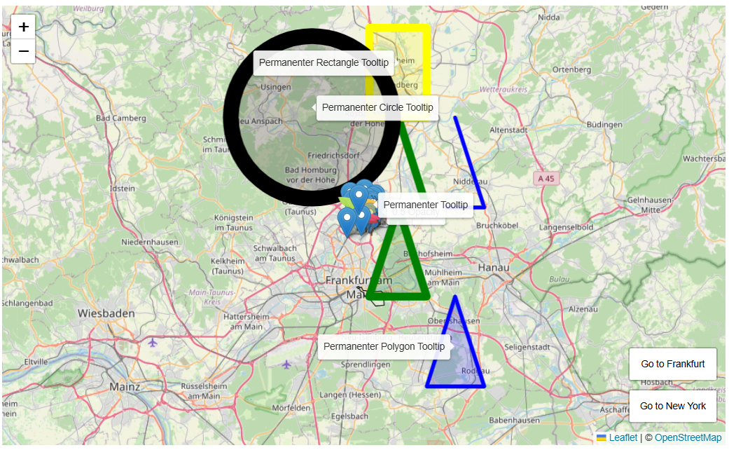 Example from the complete Test Example
Currently, the following elements are supported:
- Markers (custom icons can be referenced by ID)
- Icons
- Polylines (e.g., for tracks)
- Polygons (geometric shapes)
- Rectangles
- Circles
For advanced use cases, the map object can be accessed via a dedicated variable and manipulated using JavaScript.
For use cases see the examples
Additional features can be added upon request, depending on their relevance and feasibility.
Configuration
The adapter itself does not have any configuration options.
The configuration of the widget is described below.
vis and widgets
The following widgets actually exists
Map Leaflet- Displays map data using the Leaflet library https://leafletjs.com/.
Map Leaflet
Display of various elements on a map.
Widget configuration
| Name | Description |
|---|---|
mapwidgets_oid | Data point containing the element configuration |
mapwidgets_lat | Latitude of the map center |
mapwidgets_lon | Longitude of the map center |
mapwidgets_zoom | Initial zoom level |
mapwidgets_expose | Expose the map object under window.iobroker.mapwidgets.<widgetID>.map |
mapwidgets_maptheme | Map color scheme: automatic, light, or dark (default: automatic) |
mapwidgets_daynightenabled | Enable day/night mode |
mapwidgets_daynightcolor | Frame color for the day/night zone |
mapwidgets_daynightopacity | Opacity for the day/night zone |
mapwidgets_daynightfillcolor | Fill color for the day/night zone |
mapwidgets_daynightfillopacity | Fill Opacity for the day/night zone |
The map color scheme changes only the OpenStreetMap tile rendering. auto
follows the browser's prefers-color-scheme setting and updates when that
setting changes. light displays the original tiles, while dark applies a
dark-map filter. Markers, paths, polygons, and other Leaflet overlays are not
filtered.
Map Configuration
The map object consists of several main components, all of which can be configured independently:
{
    "marker": [],
    "icons": {},
    "polyline": [],
    "polygon": [],
    "rectangle": [],
    "circle": []
}
For testing purposes see also example\example.md for more test content.
For all configurations, the principle is that only the mandatory amount of information is required to display an element.
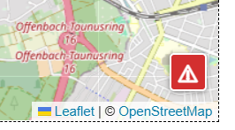
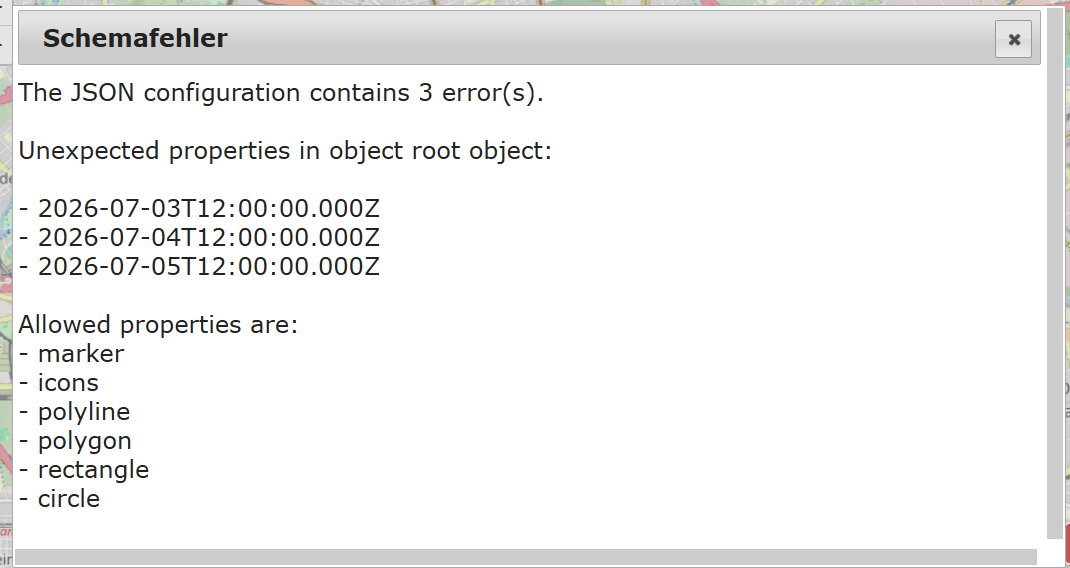
Map data is validated in edit mode. Any errors can be accessed and reviewed via the button with the red exclamation mark. This button is visible only if errors exist.
In vis, the dialog can be opened normally with a click. In vis-2, use 2 x SHIFT+click.
Button
Dialog
The assignment of the individual attributes is described below:
Marker
This contains an array of individual marker informations objects.
[
    {
        "latlng": [50.182, 8.682],
        "options": {
            "title": "Default"
        },
        "popup": "<b>Default Marker</b>",
        "tooltip": "Hover me"
    },
    {
        "lat": 50.176,
        "lng": 8.69,
        "options": {
            "draggable": true,
            "title": "Draggable"
        },
        "popup": "Drag me!"
    }
]
Latitude and longitude are mandatory; all other parameters are optional. There are 2 alternate notations for lat and lng possible, see example above.
For a custom icon, the unique ID of the icon is specified as a string
(see the icons configuration).
For Tooltip and Popup see Tooltip and Popup.
Detailed descriptions of the parameters can be found here:
https://leafletjs.com/reference.html#marker
Icon
This contains an array of object of individual icon informations.
{
    "greenleaf": {
        "iconUrl": "/vis.0/leaf-green.png",
        "iconSize": [25, 41],
        "iconAnchor": [12, 41],
        "popupAnchor": [1, -34],
        "shadowUrl": "/vis.0/leaf-shadow.png",
        "shadowSize": [41, 41],
        "shadowAnchor": [12, 41]
    },
    "orangeleaf": {
        "iconUrl": "/vis.0/leaf-orange.png",
        "iconSize": [32, 48],
        "iconAnchor": [16, 48],
        "popupAnchor": [0, -40],
        "shadowUrl": "/vis.0/leaf-shadow.png",
        "shadowSize": [50, 50],
        "shadowAnchor": [16, 48]
    }
}
iconURL is mandatory; all other parameters are optional.
The icon's key name (in the example, greenleaf) is case-sensitive,
and must be unique within the set of icons, and is used as a
reference in markers.
Allowed characters: a–z, 0–9, _, -.
Detailed descriptions of the parameters can be found here:
https://leafletjs.com/reference.html#icon
Polyline / Polygon / Rectangle / Circle
This contains an array of individual Polyline / Polygon / Rectangle / Circle informations. The schema is identical for all types. Differences are noted below.
Polyline:
[
    {
        "latlng": [
            [50.2, 8.7],
            [50.2, 8.8],
            [50.3, 8.75]
        ],
        "options": {
            "color": "green",
            "weight": 10
        }
    },
    {
        "latlng": [
            [50.2, 8.8],
            [50.2, 8.9],
            [50.3, 8.85]
        ],
        "options": {
            "color": "blue",
            "weight": 5
        }
    }
]
Polygon:
[
    {
        "latlng": [
            [50.1, 8.7],
            [50.1, 8.8],
            [50.2, 8.75]
        ],
        "options": {
            "color": "green",
            "weight": 10
        }
    }
]
Rectangle:
[
    {
        "latlng": [
            [50.3, 8.7],
            [50.4, 8.8]
        ],
        "options": {
            "color": "yellow",
            "weight": 10
        }
    }
]
Circle:
[
    {
        "latlng": [50.3, 8.6],
        "options": {
            "radius": 10000,
            "weight": 10,
            "color": "black"
        }
    }
]
latlng
The existence of this parameter is mandatory for all types.
Latitude and longitude are always an array with 2 elements [latitude, longitude], referred to as coordinates below (top-left coord and bottom-right coord).
Polyline, Polygon, Rectangle is an Array of coordinates. Circle is only a single coordinate.
A polyline must consist of at least 2 elements, a polygon of at least 3 elements, and a rectangle of exactly 2 elements.
options
Except for the Circle object, the "options" parameter is always optional. For the Circle object, the "radius" parameter is mandatory. The option of having a separate "radius" parameter at the latlng and options levels, as described in the Leaflet documentation, is not available here.
For Tooltip and Popup see Tooltip and Popup.
Detailed descriptions of the parameters can be found here:
https://leafletjs.com/reference.html#polyline
https://leafletjs.com/reference.html#polygon
https://leafletjs.com/reference.html#polygon
https://leafletjs.com/reference.html#circle
Tooltip
Tooltip for Marker, Polygon, Rectangle, Circle.
[
    {
        "lat": 50.182,
        "lng": 8.682,
        "options": {
            "title": "Default"
        },
        "popup": "<b>Default Marker</b>",
        "tooltip": "Hover me"
    },
    {
        "lat": 50.171,
        "lng": 8.695,
        "options": {
            "icon": "orangeleaf",
            "draggable": true,
            "title": "Orange dot (draggable)"
        },
        "tooltip": {
            "text": "Permanent tooltip",
            "options": {
                "permanent": true,
                "offset": [0, -12]
            }
        }
    }
]
A tooltip can be defined either as a simple string or as an object with the attributes "text" and "options".
Detailed descriptions of the parameters can be found here:
https://leafletjs.com/reference.html#tooltip
Popup
Popup for Marker, Polygon, Rectangle, Circle.
[
    {
        "lat": 50.182,
        "lng": 8.682,
        "options": {
            "title": "Default"
        },
        "popup": "<b>Default Marker</b>"
    },
    {
        "lat": 50.171,
        "lng": 8.695,
        "options": {
            "icon": "orangeleaf",
            "draggable": true,
            "title": "Orange dot (draggable)"
        },
        "popup": {
            "text": "Popup with offset",
            "options": {
                "offset": [0, -12]
            }
        }
    }
]
A Popup can be defined either as a simple string or as an object with the attributes "text" and "options".
Detailed descriptions of the parameters can be found here:
https://leafletjs.com/reference.html#popup
special iobroker options
Special options that are only supported by the Leaflet version in ioBroker are implemented using the additional options object "iobOptions". This object is not valid for all object types. Which options are valid for which object type is described in the respective section.
fitBounds
This applies to the following object types: marker, polygon, polyline, rectangle, circle.
The system collects all points of the objects, determines a minimum/maximum bounding box around them, calculates the appropriate zoom level and centers and zooms the view so that all selected objects are visible.
Example fitBounds with 3 Markers:
{
    "marker": [
        {
            "latlng": [50.2, 8.7],
            "iobOptions": {
                "fitBounds": true
            }
        },
        {
            "latlng": [50.2, 8.6],
            "options": {
                "title": "Default"
            },
            "tooltip": {
                "text": "Default",
                "options": {
                    "permanent": true,
                    "direction": "top"
                }
            },
            "iobOptions": {
                "fitBounds": true
            }
        },
        {
            "latlng": [50.2, 8.8],
            "options": {
                "title": "with Custom Icon",
                "icon": "redleaf"
            },
            "tooltip": {
                "text": "with Custom Icon",
                "options": {
                    "permanent": true,
                    "direction": "bottom"
                }
            },
            "iobOptions": {
                "fitBounds": true
            }
        }
    ],
    "icons": {
        "redleaf": {
            "iconUrl": "/vis.0/leaf-red.png",
            "iconSize": [25, 41],
            "shadowUrl": "/vis.0/leaf-shadow.png",
            "shadowSize": [25, 41],
            "iconAnchor": [14, 39],
            "shadowAnchor": [3, 39],
            "popupAnchor": [50, 50]
        }
    }
}
Location Timeline
The Location Timeline widget shows the daily location history of up to five people. Its layout is inspired by the map-and-timeline interaction used by mobile map applications, without copying a particular application design.
Each configured tracking datapoint must contain one combined WGS84 position:
50.11552,8.68417
For testing, copy
example/LocationTimeline/create-example-track.js
into a JavaScript adapter script. It creates a configurable sample day and
stores the raw positions in history.0 through storeState.
For the selected local calendar day the widget requests unaggregated values
from history.0. Day boundaries and daylight-saving changes follow the time
zone of the browser. If no history is available for today, the current state is
shown as a single marker. Past days without history remain empty.
The widget removes isolated implausible GPS jumps and groups nearby samples into stays. The following options control this processing:
- Timeline layout: automatic, beside the map, or below the map
- Color scheme (
timeline_theme): automatic, light, or dark for the timeline controls, list, and dialogs - Map color scheme (
mapwidgets_maptheme): automatic, light, or dark for the OpenStreetMap tiles only - Stay radius: maximum distance of samples belonging to a stay (default 75 m)
- Minimum stay: minimum duration of a stay (default 10 minutes)
- Maximum reasonable speed: threshold for isolated GPS jumps
(default 300 km/h;
0disables the filter)
Both color-scheme options default to auto and follow the browser's
prefers-color-scheme setting. They can be selected independently, for
example to combine a dark timeline interface with light map tiles. The map
theme does not filter route lines, markers, or other Leaflet overlays.
Known places and reverse-geocoding results are persisted in these states, which are created during adapter installation:
vis-mapwidgets.0.timeline.places
vis-mapwidgets.0.timeline.geocodingCache
IndexedDB is used as the fast local cache. State writes are collected and performed in the background. A resolved stay can be saved as a known place with an editable label and radius.
Resolved places are shown as a name plus a smaller address line. Route arrows indicate the travel direction, and both stay markers and route sections select the matching timeline entry when clicked.
External reverse geocoding is disabled by default. When enabled, the endpoint defaults to the public Nominatim reverse API. Requests are deduplicated and serialized with at least 1.1 seconds between calls. Configure a contact email and observe the Nominatim usage policy. Location coordinates are sent to the configured external service.
Utility Functions Documentation
The following functions are available under window.iobroker.mapwidgets. For example:
window.iobroker.mapwidgets.waitForGlobal(...)
window.iobroker.mapwidgets.loadScript(...)
window.iobroker.mapwidgets.loadCSS(...)
loadScript and loadCSS can be used to dynamically load JavaScript files and
CSS stylesheets, which may be necessary for using the map widgets.
waitForGlobal can be used to wait for a global variable under window..
This is necessary because the map variable is only available after
the map widget has been initialized by vis.js.
loadScript(src, { attrs = {}, timeout = 15000 } = {})
Dynamically loads an external JavaScript file into the current document.
Parameters loadScript
- src (
string)
The URL of the JavaScript file to load. - attrs (
object, optional)
Additional attributes for the<script>element. Supported keys:type: e.g."module"to load as ES module.integrity: Subresource Integrity (SRI) hash.crossOrigin: Cross-origin setting ("anonymous"or"use-credentials").
- timeout (
number, optional, default:15000)
Maximum time in milliseconds before the load attempt fails.
Returns loadScript
- Promise
Resolves when the script is successfully loaded, rejects on error or timeout. If the script is already present in the document, resolves with"already-loaded".
Example loadScript
loadScript('https://cdn.example.com/lib.min.js')
    .then(() => {
        console.log('Script loaded!');
    })
    .catch(console.error);
loadCSS(href, { attrs = {}, timeout = 15000 } = {})
Dynamically loads an external CSS stylesheet into the current document.
Parameters loadCSS
- href (
string)
The URL of the CSS file to load. - attrs (
object, optional)
Additional attributes for the<link>element. Supported keys:integrity: Subresource Integrity (SRI) hash.crossOrigin: Cross-origin setting.media: Media query for conditional loading (e.g."print","(min-width: 768px)").
- timeout (
number, optional, default:15000)
Maximum time in milliseconds before the load attempt fails.
Returns loadCSS
- Promise
Resolves when the stylesheet is successfully loaded, rejects on error or timeout. If the stylesheet is already present in the document, resolves with"already-loaded".
Example loadCSS
loadCSS('https://cdn.example.com/theme.css').catch(console.error);
waitForGlobal(path, interval = 100, timeout = 0)
Waits for a global variable (or a nested property of window) to become available.
Parameters waitForGlobal
- path (
string)
Dot-separated path to the global variable (e.g."jQuery","MyLib.utils.helper"). - interval (
number, optional, default:100)
Interval in milliseconds to check for the variable. - timeout (
number, optional, default:0)
Maximum wait time in milliseconds.0means wait indefinitely.
Returns waitForGlobal
- Promise
Resolves with the found object once available.
Rejects if the timeout is reached before the object is found.
Example waitForGlobal
<script>
    waitForGlobal('iobroker.mapwidgets.w00001.map', 200, 5000)
        .then(map => {
            // map is now available
        })
        .catch(err => console.error(err.message));
</script>
Todo
- to be defined
Changelog
0.3.3 (2026-08-11)
- remove vis dependency
0.3.2 (2026-08-10)
- switch support link to short link service
0.3.1 (2026-08-09)
- fix review problems
0.3.0 (2026-08-05)
- Added an independent automatic, light, or dark map color scheme to the Map Leaflet and Location Timeline widgets.
0.2.5 (2026-08-04)
- The dark theme has been adjusted to make the dialog easier to read.
Older entries are in CHANGELOG_OLD.md.
License
MIT License
Copyright (c) 2026 oweitman oweitman@gmx.de
Permission is hereby granted, free of charge, to any person obtaining a copy of this software and associated documentation files (the "Software"), to deal in the Software without restriction, including without limitation the rights to use, copy, modify, merge, publish, distribute, sublicense, and/or sell copies of the Software, and to permit persons to whom the Software is furnished to do so, subject to the following conditions:
The above copyright notice and this permission notice shall be included in all copies or substantial portions of the Software.
THE SOFTWARE IS PROVIDED "AS IS", WITHOUT WARRANTY OF ANY KIND, EXPRESS OR IMPLIED, INCLUDING BUT NOT LIMITED TO THE WARRANTIES OF MERCHANTABILITY, FITNESS FOR A PARTICULAR PURPOSE AND NONINFRINGEMENT. IN NO EVENT SHALL THE AUTHORS OR COPYRIGHT HOLDERS BE LIABLE FOR ANY CLAIM, DAMAGES OR OTHER LIABILITY, WHETHER IN AN ACTION OF CONTRACT, TORT OR OTHERWISE, ARISING FROM, OUT OF OR IN CONNECTION WITH THE SOFTWARE OR THE USE OR OTHER DEALINGS IN THE SOFTWARE.